


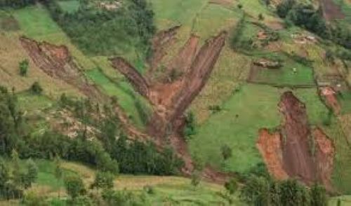
KAMPALA — The Ugandan government has set aside close to UGX 200 billion (about US$49.7 million) to begin relocating and resettling communities around Mount Elgon, on the Uganda–Kenya border, who are at risk of El Niño-induced landslides forecast to cause havoc in the last quarter of 2026 and for several months through 2027.
A high-level decision taken by cabinet ministers last week entails the relocation of more than 11,000 households from landslide-prone areas of the Mount Elgon sub-region, which lies more than 4,000 metres above sea level and borders Kenya. The sub-region contains a crack in the dormant volcanic mountain that is more than 70 kilometres long and several metres deep. It has widened and deepened over the 10 years since it was first reported in Uganda.
Uganda is one of the African countries through which the Great Rift Valley runs, from Jordan to Mozambique, and Mount Elgon lies within this geological system.
The dreaded crack runs from Mount Elgon, north-east of Mbale City—the largest urban centre in eastern Uganda—through Mount Wanale, which towers over the city to the south and south-west, and through Manafwa District to the Lwakhakha River on the Kenyan border, further east.
An online situational overview states: “The current state of the crack in Mt. Elgon in Uganda is critical, with significant environmental hazards and ongoing landslides.”
A few years ago, more than 1,000 homes were at risk of being washed down the mountain slopes or buried under rubble following concerns over a possible eruption of Mount Elgon’s dormant volcanic system. Many of these homes were built beyond the 1993 boundary of Mount Elgon National Park, which demarcates an area beyond which human habitation is prohibited. This means that many of the households currently under threat are encroachers.
The Mount Elgon crack is a significant geological concern. Reports indicate that it threatens the lives of approximately 400,000 people living in the surrounding districts, including Mbale—on and below Mount Wanale, part of the Mount Elgon system—Bududa, Manafwa, Sironko and Namisindwa.
ALSO READ Vietnamese crop breeders seek to develop world-class coffee variety in Uganda
The crack’s depth and the surrounding environment have long raised alarms about landslides and the need for urgent government intervention. The situation remains precarious, with heavy rains expected to worsen the risk of further landslides and necessitating urgent action to prevent disasters.
The Uganda Geological Survey, the Uganda National Meteorological Authority and the Uganda Wildlife Authority (UWA) have all separately confirmed the existence of the crack and its potential danger to a wide, tourism- and agriculturally rich, inhabited area.
On the morning of July 15, 2025, a phreatic eruption occurred on and around Mount Elgon’s Wagagai crater, causing significant impact across Bududa and Manafwa districts, with moderate effects reported in Bulambuli and Mbale districts. To some seismologists, these are indicators of the gradual reactivation of the centuries-old, long-dormant Mount Elgon volcano.
The last major landslide occurred on October 31, 2025, when at least nine people were reportedly killed and several others went missing after heavy overnight rainfall triggered landslides on the slopes.
The worst-affected areas were Tuikat in Kween District and Chesower in Bukwo District, in the Sebei sub-region, where homes and farmland were buried. An estimated 225 people were affected, while many others were injured.
Crops were destroyed, while water and health infrastructure were seriously affected. Rescue operations, led by local authorities, the Uganda Red Cross Society (URCS) and community volunteers, were undertaken, although persistent rain hampered search-and-recovery efforts and the mountain posed a high risk of further landslides.
The latest risks and threats—especially the anticipated El Niño rains, which are forecast to last for months—explain why the Ugandan government has approved UGX 62 billion, part of the nearly UGX 200 billion, to rescue and resettle more than 11,981 high-risk households awaiting relocation in the seven Bugisu local governments of Mbale City, Mbale District, Sironko, Bulambuli, Namisindwa, Manafwa and Bududa.
In 2025, Uganda’s Office of the Prime Minister (OPM), which is responsible for disaster management, identified a total target of 12,031 households across seven local governments that would need 28,000 acres of land for resettlement. It categorised the communities as follows: 1,423 households at very high risk and 10,558 households at high risk. It estimated that UGX 190 billion would be needed for the seven local governments, including the neighbouring Kapchorwa and Kween districts in the Sebei sub-region.
Meanwhile, a World Bank drone-mapping exercise found that more than 25 per cent of the population in the Mount Elgon area lives on moderate to steep slopes, where heavy rain can trigger slope collapse. In the worst-case scenario, if the Elgon rift or the Wanale mass collapses, researchers warn that a future Mount Elgon eruption could affect up to three million people on both the Ugandan and Kenyan sides.
Wanale, specifically, is a ridge or escarpment that is part of the Mount Elgon system and overlooks Mbale City, which has more than 120,000 residents, as well as 250,000 people in the immediate foot-slope parishes. A large Wanale block slide could bury lower Mbale within minutes. The OPM classifies this as an urban landslide risk.
The OPM further estimates that more than 50,000 to 65,000 people are at immediate risk of death and have already been identified for urgent relocation. It estimates that 250,000 to 400,000 people face chronic risk in the Bududa, Sironko, Bulambuli and Mbale–Wanale belt. If the climate worsens, up to one to three million people across the wider Elgon ecosystem could be at risk.
That is why the government is shifting from emergency response to preventive relocation, requiring beneficiaries to surrender their land to the UWA after resettlement.
However, previous government resettlement plans have faced delays for more than a decade. The fertile mountain land experiences frequent and widespread ashfalls, landslides and mudflows, which severely disrupt community livelihoods and socio-economic infrastructure.
The Minister of ICT and National Guidance, Justine Kasule Lumumba, said that in the immediate first phase, UGX 8.87 billion had been approved to purchase 2,217.66 acres of land for the first phase of the relocation programme.
The land will accommodate 1,423 households identified as being at the highest risk, particularly those living in areas where cracks have already appeared and which authorities have mapped as vulnerable to mudslides and landslides.
“Under the arrangement, each beneficiary household will choose between receiving two acres of land, valued at UGX 4 million per acre, plus UGX 10 million for the construction of a house, or receiving UGX 8 million in cash instead of land, plus UGX 10 million for construction,” she said.
However, the initial phase will cover only a fraction of the households identified as being at risk.
Relocation has been slow, with land acquisition, funding constraints, disputes over land ownership and resistance to leaving ancestral land contributing to the delays.
The government has continued to announce fresh interventions whenever landslides strike the region. In 2025, the OPM stated that the government intended to resettle 12,031 households across seven districts in the Elgon sub-region and estimated that about 28,000 acres of land would be required.
Some families at previous resettlement sites have also complained about delays in receiving land and other promised support.
Under the latest arrangement, however, beneficiaries who receive resettlement support will be required to hand over their existing land in the eruption-threatened area to the government. The surrendered land will become part of the area managed by the Uganda Wildlife Authority.
The OPM will work with local governments, the Internal Security Organisation (ISO) and Parish Development Model (PDM) structures to monitor implementation and the use of the funds. The arrangement is intended to prevent beneficiaries from returning to the same high-risk areas after receiving relocation support.
The latest intervention comes amid questions over why thousands of families remain exposed to landslides despite repeated government commitments, budget allocations and previous attempts to establish resettlement areas in safer locations. It also comes at a time when the government has previously issued El Niño alerts, in addition to announcing other plans.
The Mount Elgon ecosystem consists of red mountain laterite soils and is the catchment for several rivers, including the Suam, which becomes the Turkwel downstream and drains into Lake Turkana in Kenya. Other rivers include the Nzoia and Lwakhakha, which flow into Lake Victoria.
The important commercial, administrative, trading, industrial and farming towns of Mbale in Uganda and Kitale in Kenya lie in the Elgon foothills.
The area is also protected by two Mount Elgon national parks, one on each side of the Uganda–Kenya border.
In terms of fauna, a population of African bush elephants is present in the area and ventures deep into caves to access salt licks. This population was formerly found around the entire mountain but has since been reduced to the Kenyan side, where the elephants venture into Kitum Cave.
There are several disjunct populations of mammal species that are restricted or endemic to Mount Elgon, including the Elgon shrew (Crocidura elgonius), Rudd’s mole-rat (Tachyoryctes ruddi) and Thomas’s pygmy mouse (Mus sorella). There are also several disjunct populations of rare bird species, including Sharpe’s longclaw (Macronyx sharpei), Hunter’s cisticola (Cisticola hunteri), Jackson’s spurfowl (Pternistis jacksoni) and the Elgon francolin (Scleroptila elgonensis).
An endemic subspecies of the bushbuck, Tragelaphus scriptus heterochrous, is restricted to the mountain. The possibly extinct Du Toit’s torrent frog (Arthroleptides dutoiti), considered an EDGE species because of its evolutionary distinctiveness, is known only from a single specimen collected on the Kenyan side of the mountain.
Among the flora, some rare plants are also found on the mountain, including Ardisiandra wettsteinii, Carduus afromontanus, Echinops hoehnelii, Ranunculus keniensis and Romulea keniensis.
The Mount Elgon area is home to several communities, including the Bagisu, Mbay, Sor, Sapiiny, Koony, Someek, Pook and the Ogiek, also known as the Ndorobo.
Landslides and other destructive events cause widespread food, water and health insecurity, in addition to physical impacts, deaths and displacement.
